Customised weather and flood information at your fingertips
HydroWise user-configurable dashboards for weather monitoring, flood information, flood intelligence and flood forecasting.
HydroWise user-configurable dashboards for weather monitoring, flood information, flood intelligence and flood forecasting.
Everything you need to monitor, analyse and respond to flood events in your region.
User-configurable dashboards for adverse weather monitoring.
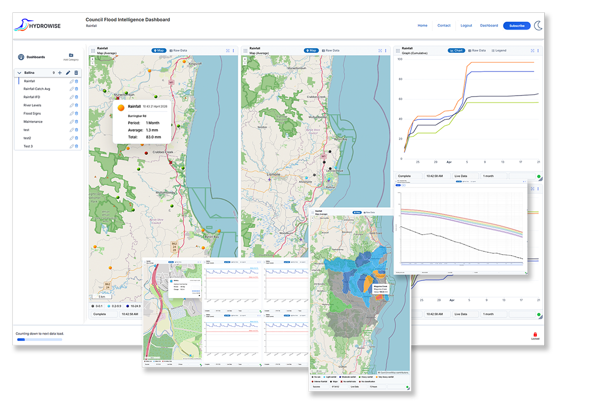
HydroWise dashboards can be configured by the user to display the data you want to see in the format you need it. Alternatively, you can select a pre-configured dashboard from a library of dashboards specific to your area of interest.
A range of subscription options to suit your needs from AU$4.60 per month.
HydroWise is a subscription based service with either monthly or annual plans. Available as either personal or professional subscription plans, the personal plan allows a single dashboard, single user plan with up to 9 data visualisations (tiles) on the dashboard. Upgrade to the professional plan for multiple dashboards and/or multiple users. Our free-community mobile app is coming soon, featuring a single dashboard with up to four data visualisations (tiles).
HydroWise accepts legacy ALERT and ALERT2 data.
HydroWise offers ALERT capability which can be used as a replacement to the retiring Enviromon software. HydroWise can be used for system maintenance (viewing battery levels and system health) and for flood emergency response. Weekly reports of system health and/or situation reports can be provided by combining with the Notifications and Reporting Module.
Online mapping system to display historical, design and/or real-time flood maps.
Online mapping system to display historical, design and/or real-time flood maps. Flood maps displayed according to observed or forecasted water levels.
Flash flood forecasting module running real-time models to predict flood levels and extents.
Flash flood forecasting module running real-time models to predict flood levels and extents. Using ALERT data, simulated results can be provided within 5 minutes of rainfall and river level observations.
Flood forecasting using ensemble modelling to show ‘almost certain’, ‘likely’ and ‘unlikely but possible’ flood scenarios.
Flood forecasting using ensemble modelling to show ‘almost certain’, ‘likely’ and ‘unlikely but possible’ flood scenarios.
Displays showing the impacts and consequences of floods.
Real-time river level observations or river level forecasts are used to display the expected flood extents whether at the presented time, or for the forecasted event. Mapping can also show the status of flooded roads, critical infrastructure and private properties. Flood intelligence is available at a catchment, municipal or street scale depending on the users needs.
HydroWise offers SMS and/or email alerting, and the automated generation of situation reports.
HydroWise offers SMS and/or email alerting, and the automated generation of situation reports. ALERTS can be configured for individual gauges or groups.